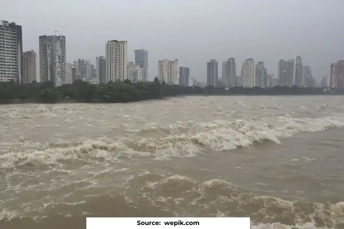
Coastal cities are already facing problems due to the rising sea levels, which cause more storm surges and even flooding on sunny days at high tide. These issues are expected to increase because it’s predicted that the average sea level will rise by at least one foot more than the levels in the year 2000 by the end of this century.
Many coastal communities around the world already live with the permanent threat of floods, which, driven by the melting of glaciers and polar ice caps, drown entire neighbourhoods, putting people’s lives at risk and causing economic havoc. And what is worse, if the world does not meet the objectives of the Paris Agreement and limits the increase in the global average temperature to 1.5 ° C by 2050, many of the cities of the planet will see this extraordinary threat multiplied.
Rising sea threat
Many cities are dealing with an additional problem that makes them more susceptible to rising sea levels: the land is sinking.
We, Pei-Chin Wu, Meng (Matt) Wei, and Steven D’Hondt, are scientists at the University of Rhode Island Graduate School of Oceanography. We’re working with the U.S. Geological Survey to study the problems faced by cities near the water. Our research shows that in many coastal cities around the world, the land is sinking faster than the sea levels are rising.
We used radar images from satellites orbiting the Earth to measure how fast the land is sinking in 99 coastal cities around the world. These rates vary a lot within cities and between different cities. But if this continues, many big cities will face flooding much earlier than predicted by models of sea level rise.
In just three decades, more than 570 coastal cities will face a projected rise in sea level of at least 0.5 meters, putting more than 800 million people at risk, according to data collected by the C40, which brings together a network of cities in the world committed to ecological transition.
Especially since, as that water level rises, the storms will become increasingly virulent. The increase in extreme weather events such as hurricanes or cyclones is a reality that breaks records every year and has a significant social and economic impact.
According to the UCCRN, a research network that brings together climate scientists from around the world, the economic costs to cities from rising sea levels and flooding could reach a trillion dollars each year by mid-century, the equivalent to the annual Spanish GDP. Estimate that they also estimate conservatively, since, for example, Hurricane Sandy in 2012 alone damaged 90,000 buildings in New York, causing 19,000 million dollars in repairs.
10 cities most affected by rising sea levels
Kolkata (India)
Kolkata, also known as Calcutta, is one of the cities most affected by rising sea levels. Built around the Hooghly River, this city is home to 14 million people, making it the third-largest agglomeration in India. The city is particularly vulnerable to flooding due to its location on the lower Ganges Delta, which used to be wetlands. The elevation varies from 1.5 meters to 11 meters above sea level, and there are many natural depressions and a malleable clay layer beneath.
Our research indicates that the land in Kolkata is sinking faster than the sea levels are rising. By using radar images from satellites, we measured the subsidence rates in 99 coastal cities worldwide. These rates vary a lot within cities and between different cities. But if this continues, many big cities will face flooding much earlier than predicted by models of sea level rise.
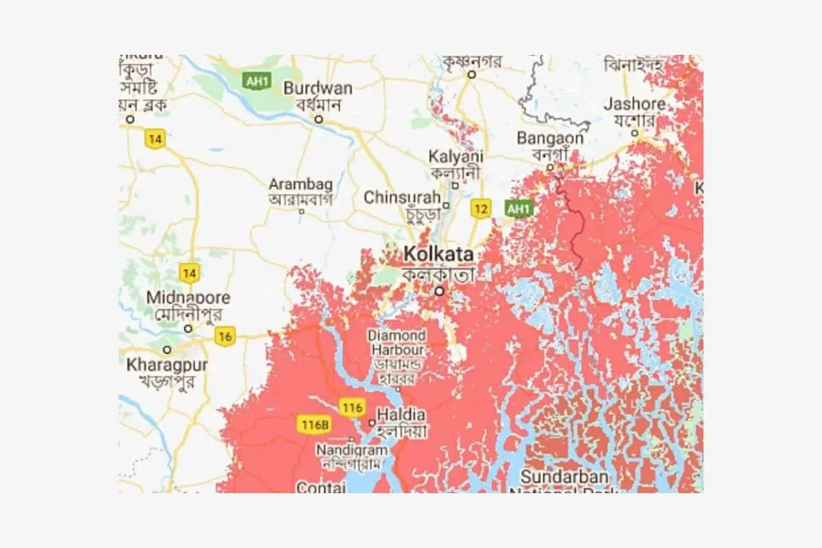
In the next 30 years, Kolkata could be the worst-hit among Indian coastal cities as sea levels rise due to global warming. New research suggests that by 2050, all of the city and its suburbs will be at risk of annual flooding, affecting many more million people than previously believed. If the scenario bears true, it could displace nearly 4.5 crore people, nearly four times the figure recorded during Partition in 1947.
Much of its history and character is due to its location in the Ganges delta, at an elevation of 0.5 to 9 meters above sea level, which is however also a curse. Periodic floods and cyclones threaten its more than 14 million inhabitants and could endanger the very existence of the city if climate change is not stopped.
2. Mumbai (India)
Mumbai, the financial capital of India, is one of the cities most affected by rising sea levels123. The city, which was once comprised of seven separate islands, was shaped through reclamation of waterlogged areas. Now, these reclaimed spaces, situated below the high water level, face a challenge during prolonged rainfall.
They set up Mumbai’s storm drainage in the early 1900s with a maximum throughput of 25 millimetres per hour, which is highly insufficient to deal with downpours reaching 993 millimetres in 24 hours.
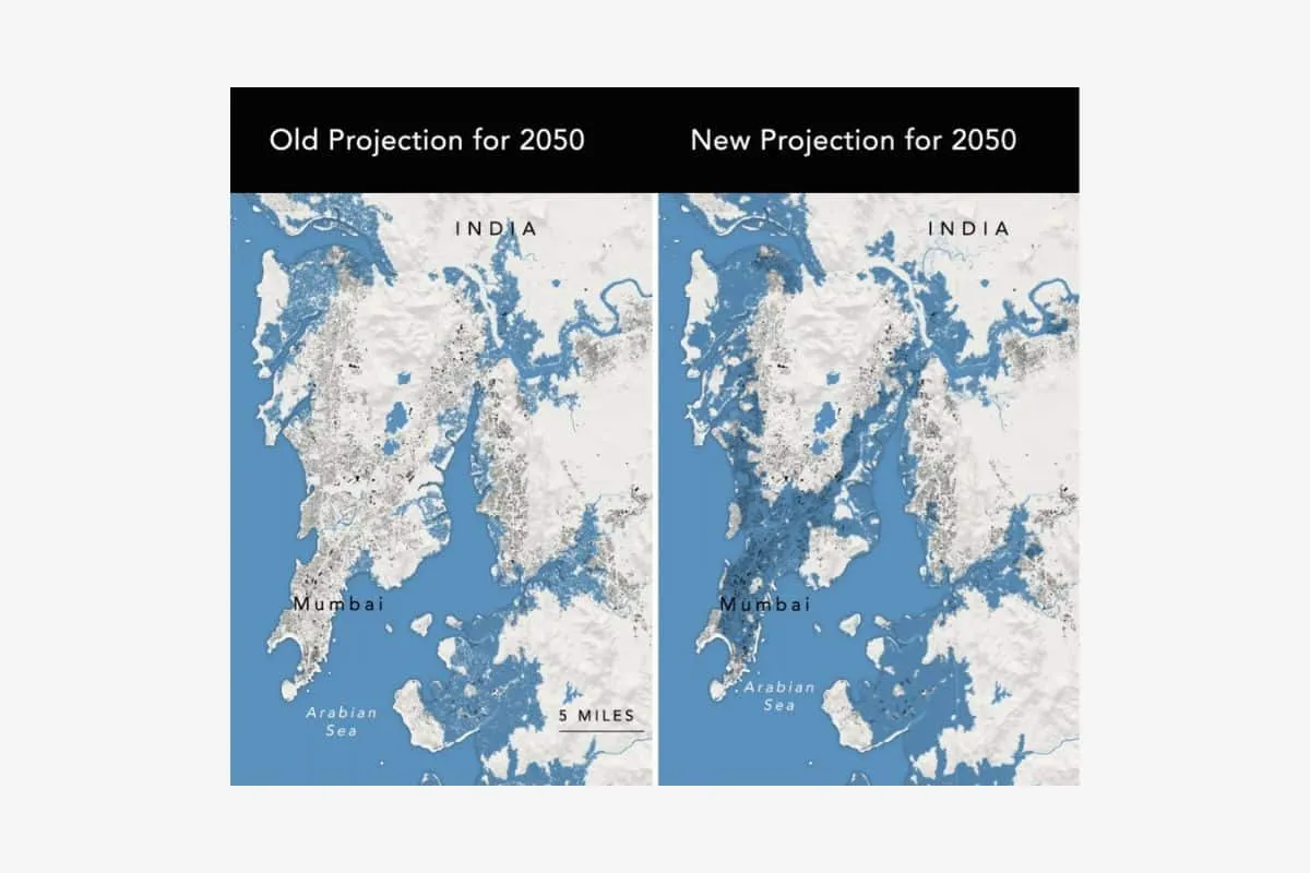
The research indicates that the land in Mumbai is sinking faster than the sea levels are rising. By using radar images from satellites, we measured the subsidence rates in 99 coastal cities worldwide. These rates vary a lot within cities and between different cities. But if this continues, many big cities will face flooding much earlier than predicted by models of sea level rise.
In the future, almost 65 per cent of Mumbai will be submerged. By 2070, Mumbai is projected to be home to over 11 million people in areas susceptible to rising sea levels and heightened flooding. That is almost four times more than the current exposed population of 2.7 million. These vulnerable residents will face the risks to their homes, livelihoods, and their basic safety2. If the scenario bears true, it could displace nearly 4.5 crore people, nearly four times the figure recorded during Partition in 1947.
3. Dhaka (Bangladesh)
Dhaka, the capital of Bangladesh, is significantly affected by rising sea levels. Located on the Ganges River Delta, Dhaka is home to a large population and is the financial and commercial hub of the country. The city, once known as the “Venice of the East” due to its natural drainage network, is now facing severe flooding events that are becoming more frequent. The land in Dhaka is sinking faster than the sea levels are rising, which is a major concern.
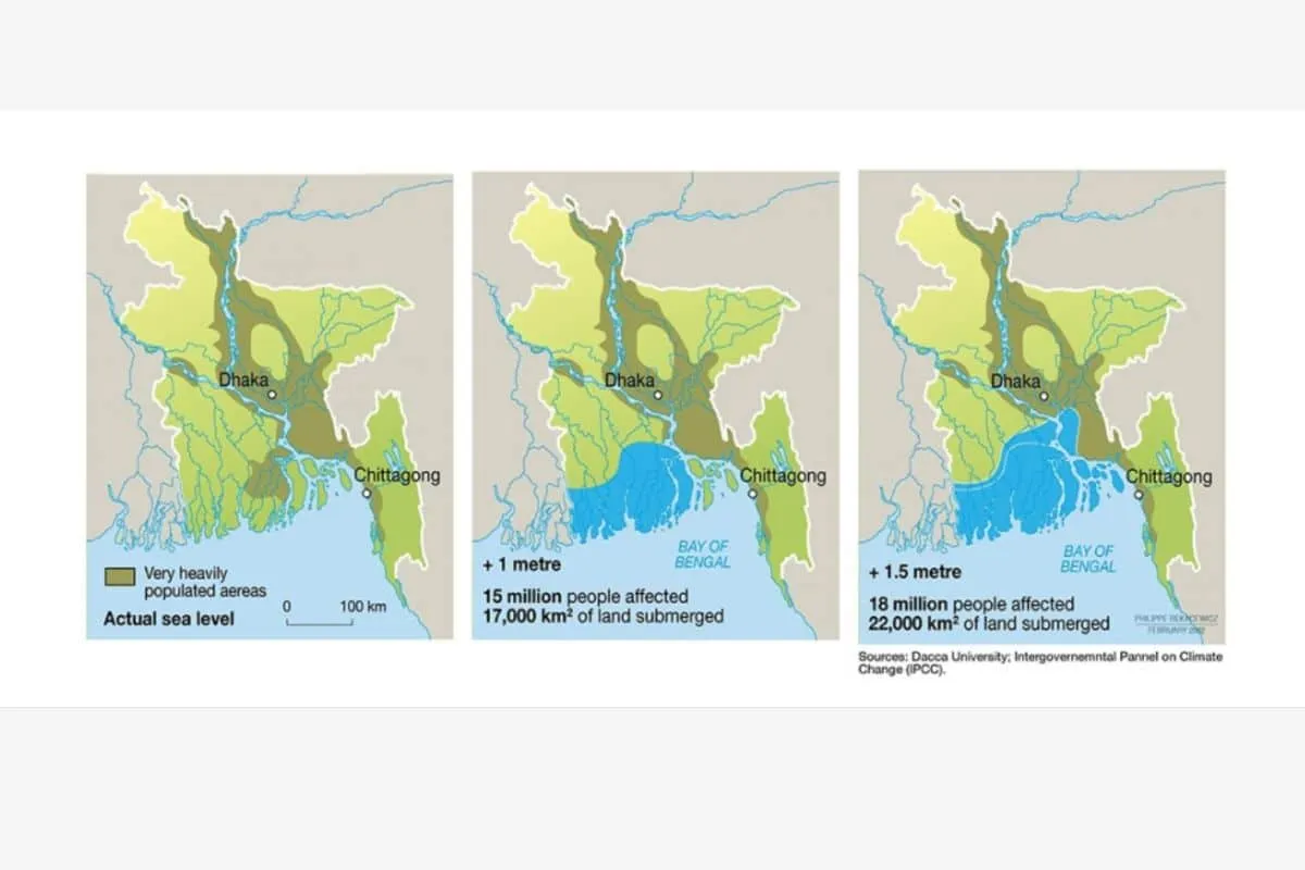
Our research indicates that poor city planning and continual expansion make it difficult for Dhaka to adapt to rising sea levels. The city’s artificial flood control systems are barely sufficient, and water reserves are contaminated with disease and industrial waste. To illustrate the looming threat, we have modeled what strong flooding would look like when combined with sea level rise by the year 2100.
By 2050, it is estimated that one in every seven people in Bangladesh will be displaced by climate change. Specifically, with a projected 19.6 inch (50 cm) rise in sea level, Bangladesh may lose approximately 11% of its land by then, and up to 18 million people may have to migrate because of sea-level rise alone. This could lead to a significant human exodus from Dhaka due to sea-level rise.
4. Canton / Guangzhou (China)
Guangzhou, also known as Canton, is one of the cities most affected by rising sea levels. Located on the Pearl River Delta, Guangzhou is home to nearly 15 million inhabitants and is a major economic hub. The city often experiences flooding due to its location on the alluvial plain of the delta. Urban expansion exacerbates such events at the expense of natural drainage systems like swamps and mangroves, but the rise in sea level is set to make things much worse.
The research indicates that the land in Guangzhou is sinking faster than the sea levels are rising. By using radar images from satellites, we measured the subsidence rates in 99 coastal cities worldwide. These rates vary a lot within cities and between different cities. But if this continues, many big cities will face flooding much earlier than predicted by models of sea level rise.
In the future, Guangzhou will have to invest in flood mitigation due to the predicted 1 to 2 metres of sea level rise. If the city does not take protective measures, severe flooding could occur by the end of the century. The upper projection of 2 metres sea level rise would displace up to 57 million people in China, most of these in Shanghai and Guangzhou.
5. Ho Chi Minh (Vietnam)
Ho Chi Minh City, the largest city in Vietnam, is significantly affected by rising sea levels123. The city experiences regular flooding during the rainy season, from May to October. Approximately 40 to 45% of the city stands less than a meter above sea level, and land subsidence due to rapid groundwater extraction is exacerbating the situation. Because they have filled up tide-draining swamps to build housing, record-breaking river tides, reaching 1.77 meters, are occurring more frequently.
Research indicates that the land in Ho Chi Minh City is sinking at a rate of 16.2 millimetres per year, while some areas have land sinking by 43 mm per year. This rate is significantly faster than the current global sea level rise of 3.7 mm per year. By using radar images from satellites, we measured the subsidence rates in 99 coastal cities worldwide. These rates vary a lot within cities and between different cities. But if this continues, many big cities will face flooding much earlier than predicted by models of sea level rise.
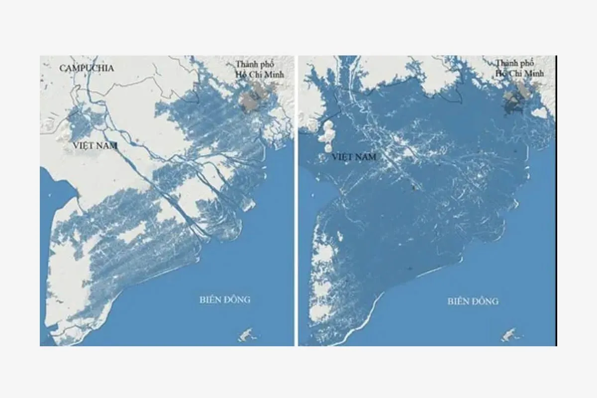
In the future, the risk of extreme future flooding events in Ho Chi Minh City could increase by up to 10 times by 2050. A recent paper published in Nature estimates that, under high emissions scenarios, global sea levels could rise by an average 1 to 2 meters by 2100. This phenomenon could put a large part of the city underwater without any kind of water surge, meaning that a 1-in-100-year flood would be disastrous.
A 2017 study states that such an event would cost USD 7.8 billion in infrastructure damage and $18 billion in real estate costs. Estimates placed the knock-on effects of the city’s shutdown at $45 billion, or a fifth of Vietnam’s GDP.
6. Shanghai (China)
Shanghai, also known as the “Venice of the East”, is significantly affected by rising sea levels. Located on the Yangtze River Delta, Shanghai is home to over 24 million people and is a major economic hub. The city has been sinking into the mud for at least 100 years, with an average rate of 22.94 mm/year from 1921 to 2007. Although land subsidence has stabilised since 2010, rising sea levels caused by global warming pose a new and very real threat to the city.
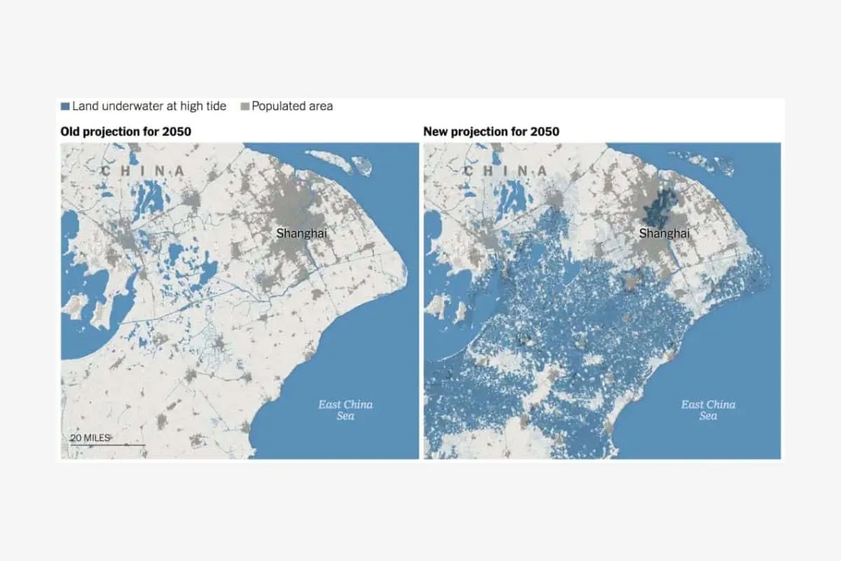
Our research indicates that the land in Shanghai is sinking faster than the sea levels are rising. By using radar images from satellites, we measured the subsidence rates in 99 coastal cities worldwide. These rates vary a lot within cities and between different cities. But if this continues, many big cities will face flooding much earlier than predicted by models of sea level rise. They project that the median relative sea level rise will be between 45 cm and 50 cm by 2050, with nearly equal contributions from both climatic and non-climatic factors.
In the future, oceans rising as a result of climate change this century will expose trillions of dollars of economic activity along China’s east coast, including $974bn in Shanghai alone. Increasing flood water levels, in turn, could increase the risks of dyke failure and associated flooding over time. For example, projections suggest that seawall failures and flood-inundated areas will increase by around 30 per cent and 50 per cent by 2100 compared to 2010.
If the delta city does not implement timely adaptation measures, catastrophic flooding could overwhelm it by the end of this century. In this scenario, flooding could cover more than 4,200 km/square (62 percent of the total area) of the city with an average inundation depth of 1.2 metres.
7. Bangkok (Thailand)
Rising sea levels significantly affect Bangkok, the capital of Thailand. They built the city on the Chao Phraya River delta, and it has an average elevation of 1.5 metres above sea level. The city is sinking at an alarming rate, with rates reaching 120 millimetres per year in 1981. Although this has been slowed thanks to more mindful practices, parts of the city are now 1 metre below sea level. Torrential rains readily fill up these lower areas, and poor drainage systems do little to mitigate severe flooding events that can persist for up to two months.
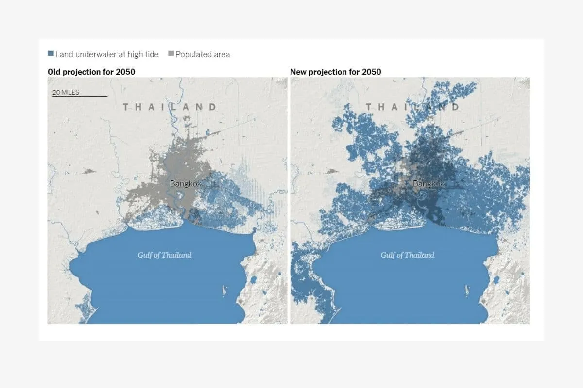
A study by the OECD predicts that extreme rainfall and changes in weather patterns will inundate nearly 40 per cent of Bangkok as early as 2030. The same study estimates that flood risk will expose 5 out of the 10 million people living in Bangkok by 2070.
If Thailand’s government is to avoid dire consequences, they must act now. Under an extreme projection, about 96% of the city will be below the mean sea level. The economic damage from such extensive coastal flooding in Bangkok would be phenomenal, as the impact to GDP could reach US$512.28 billion (17 trillion baht) and affect the lives of millions of citizens.
8. Yangon (Myanmar)
Yangon, the largest city in Myanmar, is significantly affected by rising sea levels. The city is located on the Yangon River and is an important commercial hub of the country. The city is sinking at an alarming rate, with some areas now below sea level. This, combined with the impact of climate change, has led to increased flooding events.
The land in Yangon is sinking faster than the sea levels are rising. By using radar images from satellites, we measured the subsidence rates in 99 coastal cities worldwide. These rates vary a lot within cities and between different cities. But if this continues, many big cities will face flooding much earlier than predicted by models of sea level rise. In a 2017 World Wildlife Fund summary report, experts predict sea levels will rise by anywhere from 40 to 80 centimeters by the 2080s, with a figure over 100 centimeters a possibility.
9. Miami (United States)
Rising sea levels significantly affect Miami, located in the United States. The plain between the Everglades wetlands and Biscayne Bay, broad and low-lying, hosts the city. Its citizens are already observing early signs of climate change.
A new study finds that in the coming decades, four out of five Miami-Dade County residents may face disruption or displacement due to sea-level rise, whether they live in flood zones or not.
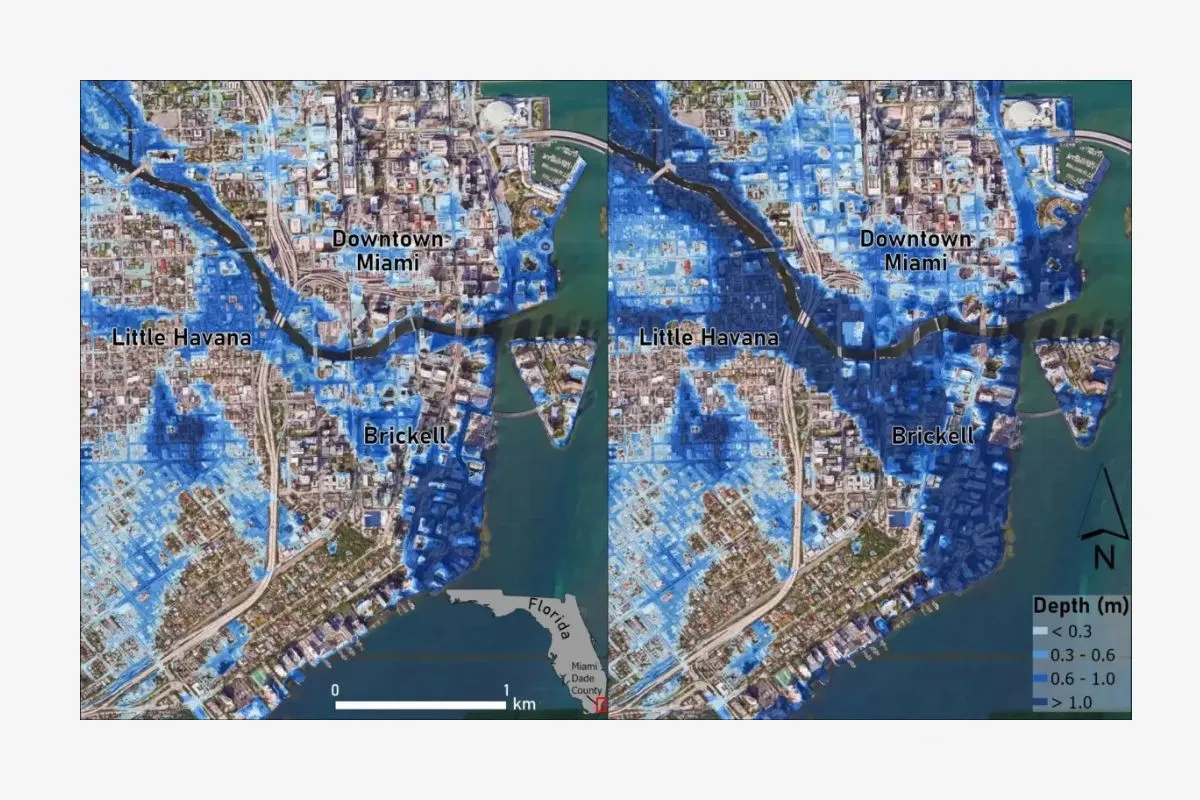
Miami is sinking faster than the sea levels are rising. By using radar images from satellites, we measured the subsidence rates in 99 coastal cities worldwide. These rates vary a lot within cities and between different cities. With a one-meter sea-level increase—a middle-of-the-road scenario for the end of this century—56 percent of the population, primarily on higher ground, could face pressures to relocate.
10. Hai Phong (Vietnam)
Hai Phong, a major port city in northern Vietnam, is significantly affected by rising sea levels. The city is located on the coast of the Gulf of Tonkin and is an important commercial and industrial hub. The city is sinking at an alarming rate, with some areas now below sea level. This, combined with the impact of climate change, has led to increased flooding events.
Phong is sinking faster than the sea levels are rising. By using radar images from satellites, we measured the subsidence rates in 99 coastal cities worldwide. These rates vary a lot within cities and between different cities. But if this continues, many big cities will face flooding much earlier than predicted by models of sea level rise. In northern Vietnam, some of Hanoi’s coastal areas, along with Hai Duong, Thai Binh, Nam Dinh, Ninh Binh and Hai Phong, will face annual ocean floods by 2050.
Keep Reading
Part 1: Cloudburst in Ganderbal’s Padabal village & unfulfilled promises
India braces for intense 2024 monsoon amid recent deadly weather trends
Support us to keep independent environmental journalism alive in India.
Follow Ground Report on X, Instagram and Facebook for environmental and underreported stories from the margins. Give us feedback on our email id greport2018@gmail.com.
Don’t forget to Subscribe to our weekly newsletter, Join our community on WhatsApp, and Follow our YouTube Channel for video stories.
