Doppler radar is a listening device that uses microwaves to “listen” for physical changes. Microwaves reflect off objects at different times depending on their position relative to the Doppler radar. Depending on how quickly the waves bounce back, an accurate image can be created. It is typically used in air traffic control, police speed control guns, and radiology. Commonly associated with meteorology, pulse Doppler can measure both distance and speed.
What is doppler radar?
This technology is based on the Doppler effect. Using this science, if a stationary object fires microwaves at a moving object, the speed of the waves will change as the position of the moving object changes. For example, if microwaves were focused on a person walking towards the radar, these waves would get higher and more frequent as the person got closer to the machine. This is because the distance between the object and the radar is shorter and the waves have less room to travel.
The reverse is also true, meaning that if a moving target were to move away from the microwave source, the waves would lengthen and shorten as the distance between the two increases. At some point, these waves can be stretched out so much that they appear flat. To create images from these microwaves, constant communication must be maintained between the radar and the object. This communication requires a continuous output and input of waves.
There are many physical uses for Doppler images. In air traffic control, waves are used to see the position of aircraft in the sky. Personal computers can interpret a constant stream of wave communication as a moving image. Air traffic controllers see aircraft in the air as moving representations of their physical locations, with only a slight delay in real-time.
Police also use Doppler radar. A radar gun fires radio waves at a moving object. These waves hit an object, such as a car, and bounce back, but instead of giving the location of the object, the waves are measured by the speed of the object. Radar guns can also be used in sports, to time runners and baseball speeds.
The medical field uses digital Doppler to save lives. In this use, electromagnetic waves are used to give doctors a visual representation of the inside of the body, without cutting through the skin. These waves can create two-dimensional (2D) or three-dimensional (3D) views of foreign organs or substances in the body. Pregnancy ultrasound uses 2D and 3D Doppler to give parents and obstetricians the first image of the baby.
As technology advanced, the science of Doppler imaging (pulse-Doppler) was created. Pulse-Doppler radar is capable of measuring both the location and speed of an object. In meteorological terms, waves bounce off clouds to measure their density, location, and speed.
How does Doppler radar work?
In radars, a light emission called radio waves is produced from a receiving wire. At the point when this bar strikes an article in the climate, the energy dissipates every which way, with some reflecting straightforwardly back to the radar.
The bigger the article avoiding the bar, the more noteworthy is how much energy the radar gets consequently. Noticing the time expected for the bar to be communicated and gotten back to the radar permits weather conditions determining offices to “see” raindrops in the air, and measure their separation from the radar.
What makes a Doppler radar exceptional is that it can give data on both the place of focus as well as their development.
It does this by following the ‘period’ of sent radio wave beats; stage means the shape, position, and type of those beats. As PCs measure the change in the stage between the first heartbeat and the got reverberation, the development of raindrops can be determined, and it is feasible to tell whether the precipitation is advancing toward or away from the radar.
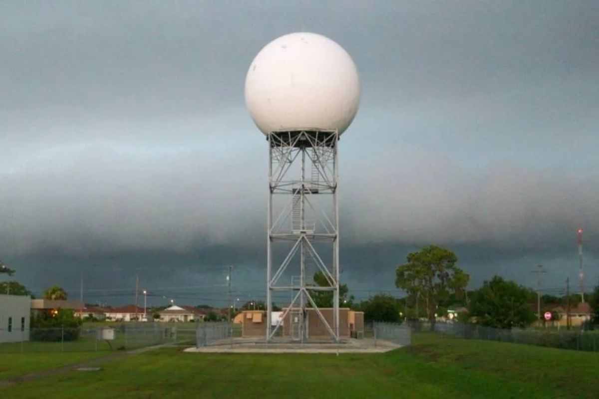
In India, Doppler radars of shifting frequencies – S-band, C-band and X-band – are usually utilized by the IMD to follow the development of climate frameworks and cloud groups, and check precipitation over its inclusion area of around 500 km. The radars guide meteorologists, especially in the midst of outrageous climate occasions like tornadoes and related weighty precipitation. An X-band radar is utilized to identify rainstorms and lightning while C-band guides in twister following.
The radar does not sample the entire atmosphere at once. Rather, the antenna makes a 360-degree rotation pointed at a particular elevation angle, then changes elevation and completes another rotation. The number and selection of elevation angles, along with the speed of the antenna’s rotation, varies based on the weather conditions.
During calm conditions, the antenna rotates slowly, completing a scan of five slices in 10 minutes. During active weather conditions, the antenna rotates faster, completing a scan of up to 14 elevation slices in 4.5 minutes. This rapid scan is crucial during developing severe weather as conditions can change by the minute.
History
Doppler radar and severe storms research were joined in the early 1960s when the National Severe Storms Project began in Kansas City, and continue to this day at the National Severe Storms Laboratory (NSSL) in Norman, Oklahoma. The Union City, Oklahoma, tornado in May 1973 marked the beginning of NSSL intercept teams using research Doppler radars to collect measurements from severe thunderstorms.
In the 1980s, the push to get Doppler radars into warning operations became well-organized as the NEXRAD (NEXt generation weather RADar) program formed. The first operational Doppler radar, the WSR-88D (Weather Surveillance Radar-88Doppler), was installed near Norman in 1988.
In the early to mid-1990s, a national network of over 100 WSR-88D Doppler radar sites was built as part of the modernization of the National Weather Service. Today, about 160 Doppler radars dot the U.S. landscape.
In recent years, these radars have been retrofitted with dual-polarization technology, firing beams aligned both horizontally and vertically. Computer programs measure the differences between the vertical and horizontal wave returns to better detect different kinds of precipitation — small raindrops, large drops, hail and snow — and other echo returns like chaff, wildfire smoke, bats, birds, insects and airborne tornado debris.
Keep Reading
Indian agriculture household earns just Rs. 10,218 in a month: Govt
Post-harvest losses still high, reveals data shared in Lok Sabha
Support us to keep independent environmental journalism alive in India.
Follow Ground Report on X, Instagram and Facebook for environmental and underreported stories from the margins. Give us feedback on our email id greport2018@gmail.com.
Don’t forget to Subscribe to our weekly newsletter, Join our community on WhatsApp, Follow our Youtube Channel for video stories.
