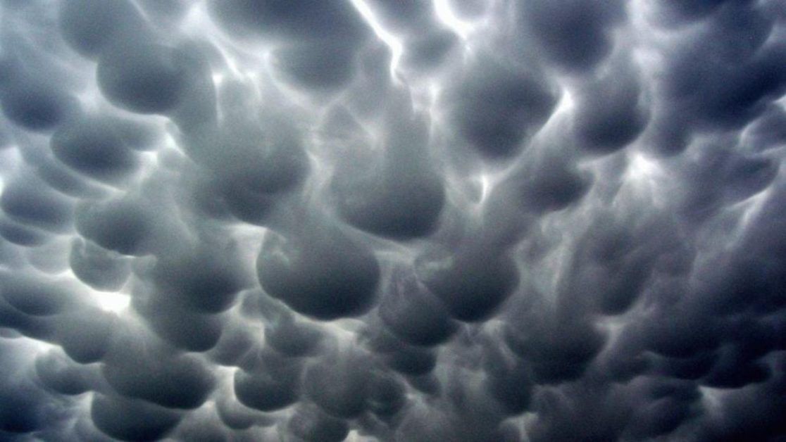
Ground report | New Delhi: What are Mammatus clouds As we know, different types of clouds are used in meteorology to know some weather predictions. Each type of cloud has its own indicator and source of formation. One of the strangest-shaped clouds is the giant cloud. They are a strange type of cloud that does not leave anyone indifferent. Meteorology amateurs and professionals both pay attention and take pictures of the strange formations that are Mammatus clouds.
In this case, it is not the cloud type, but its potential characteristics that are most important. There are many people who are amazed by the peculiar and picturesque formations of these clouds. Meteorology enthusiasts and professionals both pay a lot of attention to these types of giant-looking clouds that sometimes appear in the sky. One of the most famous examples of Mammatus clouds is a meteorological image captured by NASA in 2004 over Nebraska after a hurricane passed. This picture becomes the most representative of such a cloudy sign.
What is Mammatus clouds?
The most classic origin is of the convective type. All clouds are formed when hot air, and therefore less dense than the surrounding cold, rises like an air bubble in the water. The hot air loaded with water vapor condenses into micro-droplets that in turn deliver heat energy to the environment that surrounds it due to the heat of condensation that makes the mass even more likely to continue ascending.
The heat given off during condensation is exactly the same that the sun had to apply to achieve evaporation of the same droplet (the latent heat of evaporation). The exothermic phenomenon is brutal and causes the rising air jets to reach speeds of more than a hundred kilometers per hour and rise to the troposphere at more than 15 kilometers high.
If there are strong horizontal winds at a height of 5 or 10 kilometers, a layer of clouds is created that extends until it reaches the jets of cold air that descend around the formation of the cloud, which results in the typical anvil shape of the cumulonímbus.
ALSO READ: UP: Supreme Court notice to the government on allowing Kanwar Yatra
We are going to see how these varieties are formed depending on the environmental conditions of the atmosphere. On many occasions they appear in the residual regions of mature storms, meaning they are moving away from the observer in its most active part. Most of the areas corresponding to the breasts can be seen within the growth clouds. Usually, these clouds reach a huge vertical growth with a typical anvil-shaped structure.
When do they appear?
It is in the farthest areas from the active part of the cloud, which is strong upstream currents, with air currents appearing at the bottom. This is one reason it gives rise to the formation of these striking breasts and the characteristics of this cloud formation.
All over the sky, we have strange clouds, which in many cases are frightening and even intimidating. Infinite bumps in Mammatus clouds are formed due to the collision of strong vertical downdrafts of wind. They are not clouds that can form on their own and be a separate classified type, rather they can be formed from the clouds described above. Whenever there is a downdraft that crushes it against its natural formation growth, the lower surface will result in the formation of a lump or a section of breasts that give this curious cloud its name.
Often, as in the image that opens the news, they appear in the residual areas of mature storms, an unequivocal sign that the most active part is moving away from the observer.
ALSO READ: Model who accused Jackky Bhagnani of rape received death threats
How are they formed?
Most of the mammas are observed in the bosom of vertically developing clouds, which have acquired an enormous development, with a typical anvil-shaped structure and that in the areas furthest from the active part (the one that harbors strong updrafts) downdrafts tend to appear.
Mammatus are not a type of cloud but rather a way of presenting the base of many genera: cumulonimbus, altocumulus, altoestratus, cirrus, cirrocumulus and stratocumulus can adopt this peculiar shape: hanging protrusions, like large or small sacs that they hang from the sky.
You can connect with Ground Report on Facebook, Twitter and Whatsapp, and mail us at GReport2018@gmail.com to send us your suggestions and writeups.


