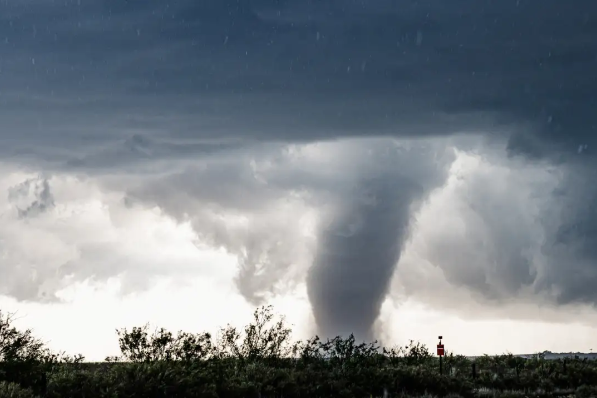
A large wedge tornado touched down Sunday evening between Bingham and Hyannis, Nebraska. Weather spotters first sighted the twister near Ashby, about 34 miles northwest of Arthur, moving east at 20 mph, according to local reports. Several storm chasers shared images and videos of the tornado on social media.
The National Weather Service (NWS) issued a Particularly Dangerous Situation (PDS) Tornado Warning for parts of Cherry and Grant Counties, citing the severity of the storm. A tornado watch remains in effect for areas of Colorado, Nebraska, and South Dakota until 11 p.m. MDT.
As of now, there are no confirmed reports of injuries or fatalities from the tornado. Local authorities and meteorologists continue to monitor the situation closely.
The NWS office in North Platte confirmed the tornado on the ground across southwestern Cherry County, northwestern Grant County, northeastern Garden County, and southeastern Sheridan County. The Tornado Warning remains active until 6:45 p.m. MDT.
Big tornado by Hyannis, Nebraska pic.twitter.com/lUFF1acdWh
— Hayden Lester (@Hayden2002WX) April 27, 2025
At 5:53 p.m., weather spotters confirmed a damaging tornado near Ashby. The storm was also capable of producing hail up to two inches in diameter. The tornado was expected to move near Ashby around 6:05 p.m. MDT and Hyannis around 6:35 p.m. MDT. Other locations in its path include Dominick Lake, Finnegan Lake, Bingham, Kincaid Lake, and Mother Lake.
Portions of Highway 2 between mile markers 124 and 151 and Highway 61 between mile markers 150 and 168 were included in the warning area.
The NWS warned that flying debris poses a serious risk to anyone without shelter. Significant damage to mobile homes, roofs, windows, vehicles, and trees is likely.
An earlier Tornado Warning, issued at 5:16 p.m., was based on a funnel cloud spotted near Ellsworth.
Meanwhile, a Severe Thunderstorm Warning remains active for parts of Cherry and Grant Counties. At 5:23 p.m., quarter-size hail was reported near Hyannis, with the storm moving north at 35 mph. Vehicle damage was expected, particularly near Hyannis and Duluth, including areas along Highways 2 and 61.
Severe weather threats are expected to expand starting Monday, April 28, impacting parts of Minnesota, Wisconsin, Iowa, and Illinois. The US Storm Prediction Center has issued a Moderate Risk (Level 4 out of 5) for these areas.
Nathan Moore’s (@StormChaserIRL) captured a view of the PDS tornado-warned storm in Nebraska moments ago. @cyclonePORT #NEwx pic.twitter.com/f4HlMi6WWD
— RadarOmega (@RadarOmega) April 28, 2025
This marks the first Moderate Risk for the region in a Day 3 Outlook since April 2011.
Major cities at risk include Minneapolis and Saint Paul in Minnesota, La Crosse in Wisconsin, and Des Moines in Iowa. Forecasts warn of strong-to-intense tornadoes, large hail, and damaging wind gusts across the upper Midwest.
Residents in affected areas are urged to monitor weather updates and seek shelter in a basement or an interior room on the lowest floor of a sturdy building, avoiding windows.
Support us to keep independent environmental journalism alive in India.
Keep Reading
The costliest water from Narmada is putting a financial burden on Indore
Indore’s Ramsar site Sirpur has an STP constructed almost on the lake
Indore Reviving Historic Lakes to Combat Water Crisis, Hurdles Remain
Indore’s residential society saves Rs 5 lakh a month, through rainwater harvesting
Follow Ground Report on X, Instagram and Facebook for environmental and underreported stories from the margins. Give us feedback on our email id greport2018@gmail.com.
Don’t forget to Subscribe to our weekly newsletter, Join our community on WhatsApp, and Follow our YouTube Channel for video stories.


