The Indian Meteorological Department (IMD) has issued an extended-range weather forecast, providing a comprehensive outlook on the current weather status and predictions for the forthcoming two weeks, spanning from March 21st to April 4th, 2024. This detailed forecast offers valuable insights into the recent climatic conditions and expected weather phenomena across various Indian regions.
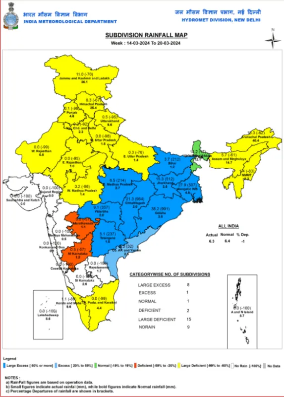
The week ending March 20th, 2024, saw significant rainfall across Eastcentral and Northeast India. Regions such as East Madhya Pradesh, Jharkhand, and others experienced light to moderate rainfall with isolated thunderstorms and gusty winds. Notably, some areas reported heavy rainfall and hailstorms, which led to a marked decrease in daily maximum temperatures recorded at 6-11°C below the norm.
The cumulative rainfall across India until March 21st was slightly below the long period average by 1%. However, the seasonal cumulative rainfall from the start of the Summer Season until March 21st, 2024, showed a 3% increase, indicating varied rainfall patterns across the country.

The Madden Julian Oscillation (MJO) index, currently in Phase 8, is expected to transition through various phases. The report indicates that these movements may not necessarily enhance convective activity in certain regions.
Two-Week Weather Forecast
Week 1 (March 21st to 27th, 2024):
“During Week 1, a cyclonic circulation situates over north Jharkhand, with a trough extending from this circulation to Manipur in the lower tropospheric levels. We observe another cyclonic circulation over Northeast Jharkhand in the middle and upper tropospheric levels. These weather systems influence the following:”
- This week, we expect light to moderate rain, isolated thunderstorms, and lightning over Arunachal Pradesh, Assam and Meghalaya, Nagaland, Manipur, Mizoram and Tripura, and Sub-Himalayan West Bengal and Sikkim.
- Expect heavy isolated rain/snow in Arunachal Pradesh, Sikkim (21st & 23rd), and Assam & Meghalaya (21st-23rd & 25th) in March 2024.
- Isolated to scattered light to moderate rainfall with isolated thunderstorms, lightning is very likely over Gangetic West Bengal, Bihar, Jharkhand, Chhattisgarh, and Odisha on 21st March, with a significant reduction thereafter.
- Isolated to scattered light to moderate rainfall with isolated thunderstorms & lightning is very likely over Tamil Nadu, Puducherry & Karaikal, and Kerala on 21st & 22nd March 2024.
The Western Disturbance, now viewed as a trough at roughly 60°E and north of 30°N, is set to impact weather. Another disturbance should affect the Western Himalayan Region from the evening of 23rd March 2024. Under its effect:
- Expect rain/snow and possible thunderstorms in Jammu-Kashmir-Ladakh-Gilgit-Baltistan-Muzaffarabad, Himachal Pradesh from Mar 21-22, less on 23-24, 2024. Likewise in Uttarakhand from 21-24. Rain predicted in Punjab on 21, 22, & 24; Haryana on 24.
- Isolated hailstorms are also very likely over Jammu-Kashmir-Ladakh on 21st and over Himachal Pradesh on 21st & 22nd March 2024.
- Strong surface winds (25-35 kmph) are very likely to prevail over Punjab, Haryana-Chandigarh-Delhi, and Uttar Pradesh on 21st March 2024.
They expect rainfall for Week 1 to be normal to above normal over northeast India, near normal over the Western Himalayan Region, and below normal over the rest of the country.
Week 2 (March 28th to April 3rd, 2024)
- A gradual increase in maximum temperatures is anticipated in North India and along the east and west coasts.
- Hot and humid conditions are expected in isolated areas of Maharashtra, Tamil Nadu, and other states on certain days.
There is a low probability of heatwave conditions in isolated pockets over Saurashtra & Kutch and West Rajasthan towards the end of Week 1. Hot and humid weather is very likely to prevail over Rayalaseema, Kerala & Mahe, Saurashtra & Kutch during most days of the week and Tamil Nadu, Puducherry & Karaikal during the 1st half of the week.
| Region | WEEK (14.03.2024 TO 20.03.2024) | SEASON (01.03.2024 TO 20.03.2024) |
|---|---|---|
| Actual | Normal | |
| East & North-East India | 11 | 12.2 |
| Northwest India | 3 | 10.8 |
| Central India | 10 | 1.6 |
| South Peninsula | 1.5 | 2.9 |
| Country as a whole | 6.3 | 6.4 |
The IMD’s report includes detailed data visualizations such as tables, charts, and maps that illustrate the rainfall and temperature scenarios, along with an extended range outlook for potential heatwaves. This information is crucial for stakeholders like farmers, disaster management authorities, and the general public, aiding in informed decision-making and the implementation of proactive measures to address the potential impacts of the forecasted weather conditions.
In summary, the IMD’s extended range forecast underscores the importance of staying informed about weather trends and preparing for the expected conditions in the weeks ahead, highlighting the need for vigilance and preparedness in the face of changing weather patterns.
Keep Reading
MP Govt step back from 2,700 per quintal wheat MSP promise, farmers angry
Niwari, MP: Hailstorm destroyed crops being fed to cattle, debt on farmers to rise
Mustard prices below MSP: farmers urge Govt intervention
Climate change is fuelling farmers’ protest across the globe
What is C2+50 Formula of MSP, How this can change life of farmers?
Follow Ground Report for Environmental News From India. Connect with us on Facebook, Twitter, Koo App, Instagram, Whatsapp and YouTube. Write us on GReport2018@gmail.com and subscribe our free newsletter.
Don’t forget to check out our climate glossary, it helps in learning difficult environmental terms in simple language.


